
Pros and Cons of ECDIS Or Paperless Navigation Of Ships
A mere 15 years back, navigators would have scoffed at the idea of Paperless Navigation on big ocean going ships. After all, since centuries, navigational paper charts had been the heart and soul of ship navigation. Imagining that a day would come where we’d no longer have them onboard was nothing short of blasphemy.
Every single navigating officer who’s been out at sea “long enough” still fondly recollects joining vessels with his own treasured Chart Correction Pen. However, the unthinkable did happen. The transition started slowly with smaller vessels like pleasure crafts, tug boats and yachts. But now, armed with the IMO mandate for compulsory ECDIS carriage, the big vessels such as the super tankers and giant container vessels are also running smoothly without paper charts. Who’s responsible for this change? Well it is none other than the Electronic Chart Display and Information System aka ECDIS.
Although, a bit biased towards the old school paper chart navigation, I cannot deny the fact that ECDIS does have an edge over paper charts. Let’s discuss some of the pros and cons of paperless navigation.
The Pros:
1. Availability: One of the great advantages of ECDIS over paper charts is the availability of electronic charts – especially when voyage orders are received at the last minute. Gone are the days when Second Mates huddled over the good old NP 131 (chart catalogue) to determine what charts they require for the voyage. This was followed by the arduous task of ordering these charts and hoping that they arrive in time. More often than not, this proved a major challenge especially on tramper trades which tend to get last minute voyage orders. With vessels going chartless, all that the Second Mate needs to do now is plot a rough course in the voyage planner and a list of all the required paper charts is populated. The Master then emails this list to the chart supplier, who will then send the activation codes for those charts. A task that with skill and practice required hours now takes a few minutes.
2. Speed and Accuracy: With ECDIS as the primary source of navigation, the Navigating Officer can plan and summarise the passage much faster than on Paper Charts. Most ECDIS units have a facility where the waypoints can be imported into an excel format which reduces the effort to manually input the waypoints when compiling the Voyage Plan. Daily reporting data such as Distance to Go, Distance Covered, Average Speed, etc. can be done quickly with hardly any effort.
3. Corrections: Before the advent of paperless navigation, the largest chunk of the Navigating Officer’s work time was consumed in Correcting Charts. Correcting charts with speed and accuracy was a skill that took a long time to master. Even then there was a possibility of the occasional erroneous correction. The Temporary and Preliminary (T&P) Notices were especially tedious since these came without tracings and required a thick file to be maintained. Keeping the world folio updated was a matter of pride which came with a lot of bragging rights. All that has changed with paperless navigation. The Navigating Officer now receives weekly updates to the Electronic Charts via Email which he has to download onto a zip drive and upload them to the ECDIS. Even the dreaded T&P notices are now shown electronically on the ECDIS.
4. Continuous Monitoring of Vessel’s Position: One of the single biggest advantages of the ECDIS over paper charts is its ability to enable the user to see the vessel’s position in real time without user action. The ECDIS is interfaced with both the vessel’s independent GPS transceivers, thereby making the system work even if one fails. However, we all know that GPS signals can be unreliable and are prone to errors occasionally. This problem can be overcome by using the Radar Overlay and Echo Referencing facility in the ECDIS and Radar. The Radars need to be interfaced with the ECDIS for this. Once this is done, the user will have to activate the overlay tab of the ECDIS which will super impose the Radar Screen on the ECDIS. By checking that the Radar Echo is matching with the ECDIS display, one can be assured that the positions can be relied upon.
Another feature enabling continuous position monitoring, especially during coastal navigation is ARPA Echo Referencing. This is done by acquiring a fixed / stationary target such as a small island, lighthouse, rock etc. on the Radar (ARPA) and then activating the ARPA tab on the ECDIS. Next step is to deselect the Secondary Position Source on the ECDIS as GPS and select Echo Reference in its place. Once enabled, this gives the user visual indication of the past tracks of both the Primary (GPS) and Secondary (Echo Reference) position fixing modes.
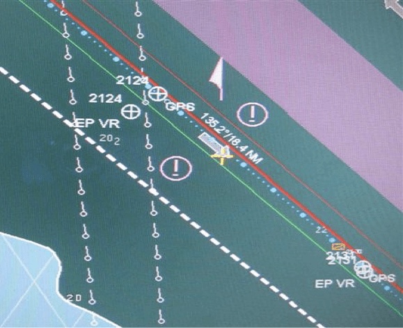
Finally, one can also use the Radar Range and Bearings to plot positions on the ECDIS display, just like on paper charts. All types of ECDIS these days come with an option of manually plotting the position using the Range / Bearing method. One simply has to take the range and bearing from a suitable radar object and plot this on the ECDIS by using the Range / Bearing function of the ECDIS itself. In ECDIS terminology, this is referred to as a Line of Position (LOP). A time stamp is printed on the ECDIS screen (see figure below) with both the GPS positions and the LOP. This serves as a ready indication of any offset present between the GPS and Radar fixes.
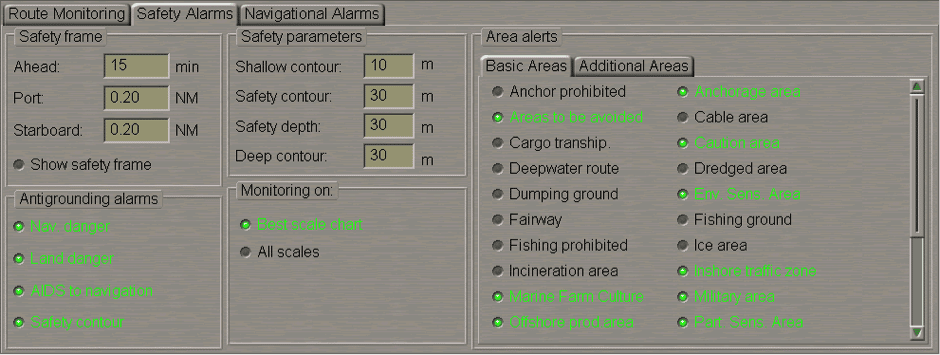
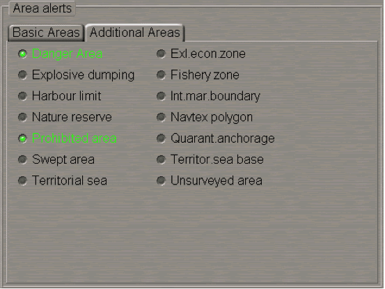
5. Anti-Grounding Alarms and Settings: Though ECDIS has now evolved into a full-fledged primary source of navigation, it was born as an Anti-Grounding aid to Navigation. Even to this day, the ability of the ECDIS to warn the user of approaching shallow waters make it one of the most useful equipment on the bridge. The user has complete flexibility to determine these safety settings on the ECDIS. Most companies’ will have strict guidelines on the minimum safety parameter settings. As a minimum, the following serves as a general guideline.
Safety Frame (Look Ahead): This is the setting which will sound an alarm if the vessel is within the limit specified. It should generally be set at not lower than 10 minutes in Open waters depending on the Speed of the Vessel. This may be lowered in coastal waters based on the situation.
Shallow Contour: This setting indicates the non-navigable area and marks the boundary outside of which the vessel may safely navigate. Crossing this boundary will result in the vessel running aground. Is usually indicated by a Deep Blue Colour which marks the non-navigable area. Usually set to a value of the present deepest draught of the vessel (without any squat or ukc factored in).
Safety Depth: This marks and highlights the minimum depth required for the vessel to remain safely afloat. As a thumb rule, Safety Depth = Deepest Static Draught + Anticipated Squat + Company’s Min UKC.
Safety Contour: In general, the Safety Contour may be set equal to but not lower than the Safety Depth setting. Waters with depths lower than the Safety Contour should be construed as No-Go Area. The Master may set the Safety Contour to a value higher than the Safety Depth if he determines that an additional safety buffer would be required depending on the prevailing circumstances and conditions. Indicated by a Grey Coloured area on the ECDIS.
Deep Contour: This setting is very handy for vessels engaged in operations such as Tank Cleaning or Ballast Water Exchange where it is mandatory to carry out the operation in waters exceeding a certain depth. Vessel’s not engaged in such operations may set this value as deemed appropriate but in any event this should not be lower than the Safety Contour. Indicated by a white coloured area on the ECDIS screen.

Colour Coded Indications of the Deep Blue Shallow Contour (18 mtrs), Grey Safety Contour (20 mtrs) and the White Deep Contour (30 mtrs).
6. User Determined Alarm Settings: While there are certain safety critical alarms that are ON by defaults and cannot be changed, there are a host of other alarms and warnings which may be switched on or off by the User depending on the situation. Prudence should be exercised when activating / deactivating alarms and warnings. Too many alarms could result in Alarm Deafness (more on this later) and too few alarms might result in a false sense of Safety. It is of utmost importance that the Navigational Watchkeeping Officer is fully familiar with all the Alarms and Warnings which have been activated. A handover checklist of the alarms and warnings should be completed before taking over the watch. Prior taking over the watch, it is essential to note down what warnings / alarms are already in place.
Example of Alarms ( Image Credits Transas Navisailor ECDIS Manual):
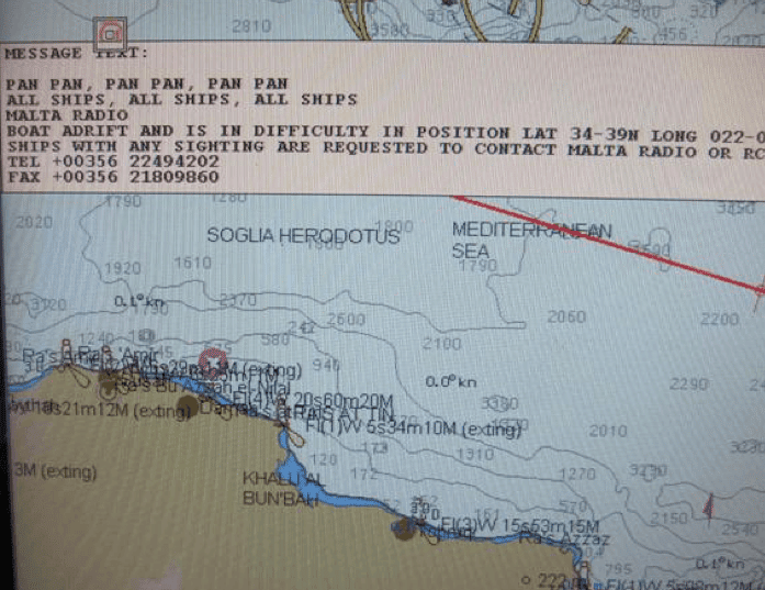
7. Enhances Search and Rescue Capability onboard: Modern ECDIS units have the option of interfacing NAVTEX and EGC with the ECDIS display. Warnings and Alerts are automatically displayed on the ECDIS screen, whilst at the same time giving an audible and visual indication on the unit itself. Quick Range and Bearings are obtained by the Electronic Range and Bearing Line (ERBL) function. This enables the user to quickly determine if the vessel is in a position of providing assistance to the distressed craft.
The ECDIS unit also has a Man Overboard (MOB) function which can be activated in the event of a person falling overboard. This marks the position / datum which is used as a reference for Recover and Rescue.
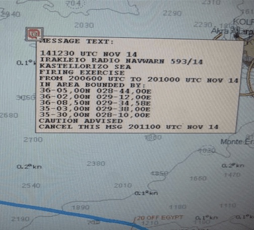
Eg. Of NavWarning on ECDIS
Eg. Of Navtex SAR Message on Ecdis
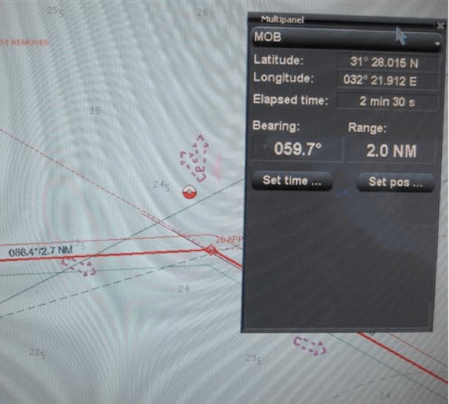
Eg. Of Man Overboard Function in ECDIS
8. Cost Efficient: Although, Electronic charts are by no means cheap, they still have an edge over paper charts dollar for dollar. Electronic Chart Permits are obtained electronically with minimum data usage. Paper charts though, have to be delivered physically which involved handling fees by the agents, especially if ordered at the last minute. On rare occasions vessel’s had to divert only to pick up charts if the voyage was changed at the last minute. This involved massive costs such as Agency fees, Boat costs etc. All this can be avoided by using Electronic Charts.
9. Environmentally Friendly: Remember having to dispose of all those old charts many of which were never used? Now imagine hundreds and thousands of vessels doing the same. Not to mention the phenomenal amount of paper that is used to print out blocks, tracings and T&P notices. This doesn’t happen with the ECDIS. The ECDIS does pack in a strong punch in reducing the carbon footprint of every vessel which goes paperless.
Now everything can’t be hunky dory, can it?
Here are some of the things that go on to prove that nothing in this world is perfect. No, not even the ECDIS!
Cons:
1. Over-Reliance: With an equipment which is seemingly fool-proof, there is a tendency for navigators to over rely on it. The consequences can be disastrous. Every once in a while you see an erring Third Mate tunnel visioned on the ECDIS. The ability and need to keep a proper visual look out cannot be over emphasised here. No matter how good the ECDIS is, its performance still largely depends upon the inputs. A vessel could have switched off its AIS and hence might not be displayed on the ECDIS. If the Radar Overlay is not turned on, the vessel will just not be seen on the ECDIS display. Hence, it is very critical that Navigators continue to maintain an efficient lookout and a good radar watch. The purpose of the ECDIS is to facilitate efficient navigation, not to substitute it. It is still vitally important to practice essential skills such as Radar Plotting, Sights, Compass Errors etc which will come in handy in the event of an ECDIS breakdown. Also, it is very important to go through the company’s procedures in the event of ECDIS failure.

2. Garbage In Garbage Out (GIGO): ECDIS at the end of the day, is a machine and depends solely on the type of inputs that it receives. Erroneous position inputs from the GPS or loss of GPS signal can have grave consequences with the ECDIS going in DR mode. If the alarm is missed out, the result can be disastrous. Hence, it is vitally important to check the performance of sensors and to carry out frequent comparisons between the primary and secondary means of position fixing. Other inputs such as the GYRO, Anemometer, Echo Sounder, Navtex, etc should be frequently verified independently to ensure smooth operation.
3. Wrong Settings: Feeding in wrong parameters for safety critical settings such as the Safety Depths, Safety Contours etc can give a false sense of safety. It is extremely important that the Master himself checks these settings each time they are changed. These settings should be password protected and every Navigator should verify them each time prior taking over the watch. Alarms should not be deactivated without strong reason and never just for the sake of avoiding frequent alarms. All the alarms in use should be properly documented and their switching on and off should be controlled by a defined procedure.
4. Alarm Deafness: If alarms start going off too frequently, the navigator could end up in a dangerous situation called Alarm Deafness. This leads to the watch keeper acknowledging the alarm even without checking what it was. He will eventually run out of luck and there could be an occasion where he might miss out on a critical warning such as approaching shallow contour. Hence, alarms should be carefully chosen which are appropriate to the prevailing conditions. Every single alarm should be checked and investigated prior acknowledging.
5. System Lag: Modern ECDIS software can have a lot of data to display. And with various equipment interfaced with the ECDIS, the system can slow down very easily leading to system lag. The hardware needs to keep up with the software and frequent upgrades are necessary. A higher RAM and a higher graphics card is a must.
6. Different Types: Navigation on paper charts was a skill which had to be mastered just once. It was then just routine practice which kept one in tune with things. However, this does not happen with ECDIS. Different vessels will have different types of ECDIS equipment. Even if the essential features are the same, it still takes a lot of fiddling around until one gets comfortable with the machine. With today’s busy schedule, it is not uncommon for navigators to take over duties at the gangway itself. It is then left to colleagues onboard to familiarise him with various equipment. To overcome this problem, many flag states have made it mandatory for every seafarer to undergo type specific ECDIS training prior joining the vessel. Type Specific training has to be imparted by the equipment manufacturer and cannot be substituted by onboard training by the Master. Logistically, it is extremely difficult for every navigator to undergo this type specific training especially when there is a need to embark on a short notice. A work around is that some companies have decided to select a single Equipment manufacturer to supply the company’s fleet with ECDIS equipment. (Eg. Maersk Tankers has chosen TRANSAS as their supplier). This eases the training bottleneck considerably.
7. Anomalies: Every navigator needs to be aware of the anomalies present in that particular equipment. It could be a simple use of the SCAMIN (Scale Minimum) function or something serious where certain depths or symbols might not be visible at a particular scale or appear differently. Complete familiarisation with the ECDIS equipment is a must.
8. Information Overload: It is very easy to over feed information on the ECDIS. A lot of data which was earlier marked on charts such as position for calling Master, notices to Engine Room, Echo Sounder Switch on points, Port Control VHF channels etc now have to be fed on the ECDIS. The user needs to be aware that some of this information can be missed out in the clutter of information already present on the ECDIS. Larger ECDIS screens and better use of the Passage Plan Hard Copy should be used as a workaround.
9. Resistance to Change: Although this sounds like a trivial issue, it can be quite problematic. Most of the present day navigators have grown up in an era where paper charts was the only means of navigation. Not having these onboard could for them mean not having an aid on which they have relied all their lives. The transition cannot be easy and this could create a mental block for many. Hence it is vital, that senior navigators embrace this new technology with open arms and do their bit to improve the process of change. Shipping companies, flag states and Training Institutes need to identity this issue and encourage senior seafarers to undergo frequent refresher courses.
All said and done, ECDIS is here to stay. This is the future and one cannot just wish it away. As the saying goes,” if you can’t win them, join them”. It is in every navigator’s interest to join in on the ECDIS bandwagon. It cannot be disputed that even with all its follies, ECDIS is a fantastic piece of equipment and is here to stay.
marineinsight.com